File:Vegetation.png

Size of this preview: 800 × 359 pixels. Other resolutions: 320 × 144 pixels | 640 × 287 pixels | 1 385 × 622 pixels.
Original file (1 385 × 622 pixels, file size: 85 KB, MIME type: image/png)
Isishwankathelo
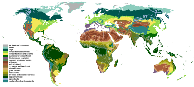
| Inkcazo | The main biomes in the world. Drawn by hand using maps. |
| Umhla | |
| Imvelaphi |
The blank world map in Commons and WSOY Iso karttakirja for the information. Referred to over a hundred sources, but here are some of the more extensively used ones: [1], [2], [3], [4], [5], [6], [7], [8], [9], [10] |
| Umbhali | Ville Koistinen (user Vzb83) |
| Other versions |
Derivative works of this file: |
![[5]](https://www.surfaceview.co.uk/storage/image/VMA0018.jpg)
![[6]](https://upload.wikimedia.org/wikipedia/commons/4/4f/Vegetationszonen.png)
![[7]](https://esdac.jrc.ec.europa.eu/images/Eudasm/Africa/images/maps/download/afr_veg.jpg)
![[8]](https://www.researchgate.net/profile/Julie-Morin-9/publication/319979374/figure/fig2/AS:614404802478081@1523496928789/UNESCO-AETFAT-UNSO-Whites-vegetation-map-of-Africa-The-Guineo-Congolian-regional.png)
![[9]](https://www.researchgate.net/profile/Andrea-Kay/publication/276452894/figure/fig1/AS:623557285523457@1525679050775/Map-of-study-area-showing-modern-potential-natural-vegetation-simplified-from-White.png)
![[10]](https://i.pinimg.com/originals/5d/b3/b5/5db3b5b71e47b5467d8df815cd525df5.png)

|
This biogeographical map image could be re-created using vector graphics as an SVG file. This has several advantages; see Commons:Media for cleanup for more information. If an SVG form of this image is available, please upload it and afterwards replace this template with
{{vector version available|new image name}}.
It is recommended to name the SVG file “Vegetation.svg”—then the template Vector version available (or Vva) does not need the new image name parameter. |
ukunika imvume
I, the copyright holder of this work, hereby publish it under the following licenses:

|
Permission is granted to copy, distribute and/or modify this document under the terms of the GNU Free Documentation License, Version 1.2 or any later version published by the Free Software Foundation; with no Invariant Sections, no Front-Cover Texts, and no Back-Cover Texts. A copy of the license is included in the section entitled GNU Free Documentation License. |
| This file is licensed under the Creative Commons Attribution-Share Alike 3.0 Unported license. | ||
| ||
| This licensing tag was added to this file as part of the GFDL licensing update. |
This file is licensed under the Creative Commons Attribution-Share Alike 2.5 Generic, 2.0 Generic and 1.0 Generic license.
- Khululeka/ukhululekile
- Yabelana nabanye – to copy, distribute and transmit the work
- to remix – to adapt the work
- Phantsi kwezi meko zilandelayo
- attribution – You must give appropriate credit, provide a link to the license, and indicate if changes were made. You may do so in any reasonable manner, but not in any way that suggests the licensor endorses you or your use.
- share alike – If you remix, transform, or build upon the material, you must distribute your contributions under the same or compatible license as the original.
You may select the license of your choice.
File history
Click on a date/time to view the file as it appeared at that time.
| Umhla/ixesha | Thumbnail | Dimensions | User | Khawuphawule | |
|---|---|---|---|---|---|
| Ngoku | 18:55, 24 EyoKwindla 2024 | | 1 385 × 622 (85 KB) | Berkserker | Added more level of detail, particularly to montane and arid regions. Corrections to savannas. |
| 21:44, 18 Eyo Msintsi 2023 |  | 1 385 × 622 (81 KB) | Berkserker | Minor correction to key | |
| 21:01, 18 Eyo Msintsi 2023 |  | 1 385 × 622 (80 KB) | Berkserker | Slight correction to Eastern Australia | |
| 09:37, 11 EyeThupha 2020 |  | 1 385 × 622 (80 KB) | Berkserker | Corrections to Madagascar | |
| 18:35, 6 EyeThupha 2020 |  | 1 385 × 622 (80 KB) | Berkserker | Minor optimization according to Dyer 2006 | |
| 07:01, 5 EyeThupha 2020 |  | 1 385 × 622 (80 KB) | Berkserker | Added a third source: Dyer 2006, specifically to address the issues in Eastern USA | |
| 03:40, 15 EyeSilimela 2020 |  | 1 385 × 622 (80 KB) | Berkserker | More corrections as well as fixing remaining dead pixels | |
| 13:22, 9 EyeSilimela 2020 |  | 1 385 × 622 (80 KB) | Berkserker | Further corrections based on the same sources | |
| 07:20, 21 EyoKwindla 2020 |  | 1 385 × 622 (80 KB) | Berkserker | Minor correction to Andean montane forests | |
| 07:09, 21 EyoKwindla 2020 |  | 1 385 × 622 (80 KB) | Berkserker | Fixed key and map colors not matching |
Ukusetyenziswa kwale file
Akukho maphepha asebenzisa ezi nkcukacha
Global file usage
The following other wikis use this file:
- Usage on bh.wikipedia.org
- Usage on bn.wikipedia.org
- Usage on bs.wikipedia.org
- Usage on ckb.wikipedia.org
- Usage on cs.wikipedia.org
- Usage on el.wikipedia.org
- Usage on en.wikipedia.org
- Usage on en.wikibooks.org
- Usage on et.wikipedia.org
- Usage on eu.wikipedia.org
- Usage on fa.wikipedia.org
- Usage on fr.wikipedia.org
- Usage on hi.wikibooks.org
- Usage on ik.wikipedia.org
- Usage on ku.wikipedia.org
- Usage on mk.wikipedia.org
- Usage on mt.wikipedia.org
- Usage on no.wikipedia.org
- Usage on oc.wikipedia.org
- Usage on om.wikipedia.org
- Usage on pnb.wikipedia.org
- Usage on ps.wikipedia.org
- Usage on pt.wikipedia.org
- Usage on si.wikipedia.org
- Usage on ta.wikipedia.org
- Usage on th.wikipedia.org
- Usage on tr.wikipedia.org
- Usage on ur.wikipedia.org
- Usage on vi.wikipedia.org
- Usage on vls.wikipedia.org
- Usage on war.wikipedia.org
- Usage on www.wikidata.org
- Usage on zh-yue.wikipedia.org
- Usage on zh.wikipedia.org