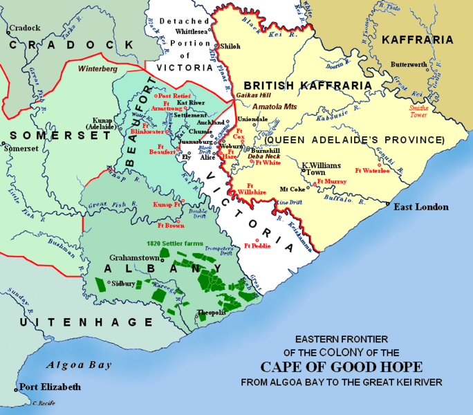
Ngokweenkcukacha:Eastern Frontier, Cape of Good Hope, ca 1835.png

Size of this preview: 684 × 600 pixels. Other resolutions: 274 × 240 pixels | 548 × 480 pixels | 836 × 733 pixels.
Original file (836 × 733 pixels, file size: 279 KB, MIME type: image/png)
File history
Click on a date/time to view the file as it appeared at that time.
| Umhla/ixesha | Thumbnail | Dimensions | User | Khawuphawule | |
|---|---|---|---|---|---|
| Ngoku | 00:57, 13 EyoMqungu 2021 |  | 836 × 733 (279 KB) | JMK | add label |
| 11:41, 13 Inyanga kaCanz... 2019 |  | 836 × 733 (278 KB) | JMK | Change map colour east of Great Kei River (based on comments received), as it was never part of British Caffraria. Other minor changes. | |
| 11:47, 30 Eyo Mnga 2007 |  | 836 × 733 (253 KB) | JMK | Update | |
| 10:58, 26 Eyo Mnga 2007 |  | 836 × 733 (257 KB) | JMK | {{Information |Description=Eastern frontier of the Colony of the Cape of Good Hope from Algoa Bay to the Great Kei river *Settled colonial area shown in green, with districts established in 1820 shown in different shades of green *Neutral zone agreed on b | |
| 10:55, 26 Eyo Mnga 2007 |  | 836 × 733 (257 KB) | JMK | {{Information |Description=Eastern frontier of the Colony of the Cape of Good Hope from Algoa Bay to the Great Kei river *Settled colonial area shown in green, with districts established in 1820 shown in different shades of green *Neutral zone agreed on b |
Ukusetyenziswa kwale file
The following page uses this file:
Global file usage
The following other wikis use this file:
- Usage on af.wikipedia.org
- Usage on ca.wikipedia.org
- Usage on de.wikipedia.org
- Usage on en.wikipedia.org
- Usage on eo.wikipedia.org
- Usage on es.wikipedia.org
- Usage on fa.wikipedia.org
- Usage on fr.wikipedia.org
- Usage on he.wikipedia.org
- Usage on it.wikipedia.org
- Usage on ja.wikipedia.org
- Usage on mk.wikipedia.org
- Usage on nl.wikipedia.org
- Usage on ru.wikipedia.org
- Usage on sv.wikipedia.org
- Usage on uk.wikipedia.org
- Usage on www.wikidata.org


